TRAILS
Call Before You Dig
The RCMBA community has worked hard to bring about the trails that you see today. We have forged some great relationships with our partners, including the Bureau of Land Management, Green Diamond Resource Company, the County of Humboldt, and the City of Arcata to name a few. We strive to keep growing our relationships with landowners and to keep expanding our trail systems throughout the area. Creating unsanctioned trails and features within our trail networks jeopardizes these relationships and therefore access to trails. We are open to ideas you may have for entirely new trails or features on existing trails, and we would love to harness that energy in a sanctioned and sustainable way.
Before you dig, please contact us!
Trail Maps & Information
Our corner of Northern California offers a multitude of riding options, and we are working hard every day to bring more to the table. For now, check out the trail maps and links to some of the amazing riding available now. You just have to pedal out that door.
Hatchery Ridge (Blue Lake)
This is the true gem of RCMBA’s work to bring more trails to our area. Located in beautiful, sunny Blue Lake, California, this trail system hosts some of the funnest, gnarliest, loamiest trails we have to offer. You must be a member of RCMBA to ride these trails. Please do adhere to our land use agreement with Green Diamond Resource Company so that we can continue to grow our relationship with GDRC and hence grow our riding opportunities.
Lindsay Creek Bike Trails
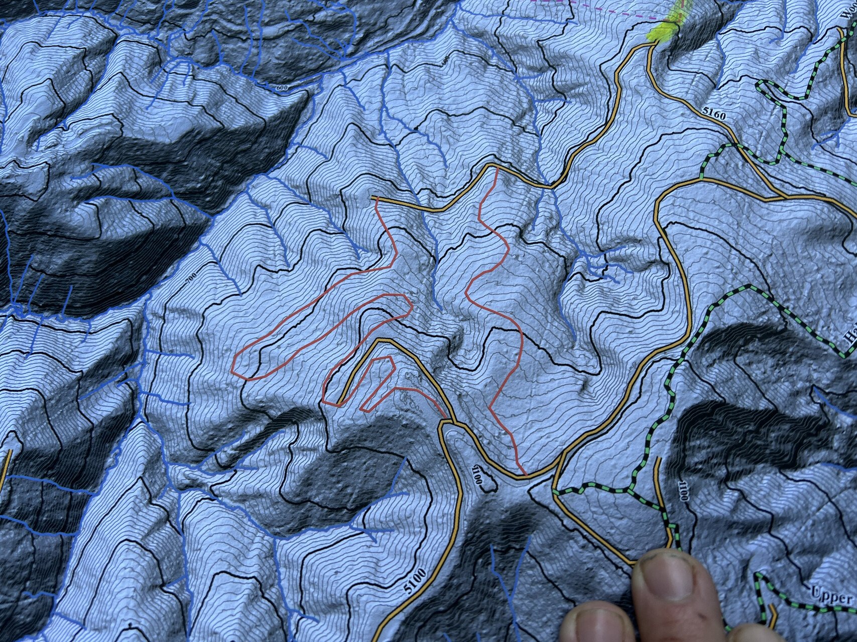
The Lindsay Creek Bike Trails system is located east of McKinleyville, up the hill towards Fieldbrook, and partially behind Beau Pre Golf Course. There are 43 potential trails and 28 existing/named trails that are in need of MTB-optimization, maintenance, and repair. The two portions of property RCMBA members can access are owned by Green Diamond Resource Company and DANCO Builders. Permission to access, ride, and build trails is granted to RCMBA members through an exclusive agreement between the club and the property owners. Parking is available along Murray Road in multiple locations.
The trail system is divided by Murray Road, which separates two distinctive types of terrain. The north side of Murray is tight single-track on mostly loamy trails, with slow tech sappy root climbs and XC loops galore. There is also one slopestyle area.
The southside is much faster, offering skid road bombs, jump lines, and singletrack sprinkled with small jumps and berms. You will also find our big gap jumps and slopestyle, MTB and BMX jump pits on the southside.
Our current trail focus is on completing a new trail (#29, aka Fizzgig), and a 2-way flow/climbing trail along Murray Road. Our hope is that these newer trails will be adopted into what will ultimately become the McKinleyville Community Services District’s newly designated McKinleyville Community Forest.
The below links are to the current maps. The maps are georeferenced and can be used in phone apps like Avenza.
Lacks Creek Management Area Trails
While it is a little bit of a drive, Lacks Creek Management Area offers higher elevation and well-draining rocky, loamy, and loose soils. There’s literally a trail for everyone here. If you want a beginner flow trail, Lacks has that. If you want fast, steep, rocky descents, Lacks has that. If you want a flowy jump run, Lacks has that. In addition to all of that, Lacks also hosts primitive camping. So come camp for the weekend, relax, get eaten by a few mosquitoes, and have a biking adventure.
Arcata/Sunny Brae Community Forests
The Arcata and Sunny Brae Community Forests offer some grueling climbs and fun and fast descents. Due to the popular shared use of all the trails in these systems, we do recommend that riders shout with joy while descending or wear a bell to let hikers know you’re coming. Please share the trails responsibly.
Arcata Community Forest Website
Arcata Community Forest Map (City Map)
Arcata Ridge Trail Map (City Map)
Sunny Brae Community Forest Map (City Map)
Paradise Royale
Paradise Royale is repeatedly listed in the top 30 best trails in California. While it is a bit of a drive down a very windy paved road and then a rough gravel road, you will not be disappointed. This trail comes with a grueling climb, but a fun, fast, flowy descent that seems to go on forever, though that might be delirium from the climb talking. Add a little spice to it by adding an out and back on the Paradise Rim Trail. Best yet, camp at the Tolken Campground and enjoy the terrain park hosting wall rides, table top and gap jumps, skinnies, and a variety of other obstacles to improve your skills. Nearby Shelter Cove hosts a fantastic brewery, vacation rentals, and breathtaking views of the ocean. Coming hopefully sooner than later will be a trail that flows from Kings Peak all the way into Shelter Cove (a nearly 4,000 foot descent) making this yet another mountain biker’s paradise.